

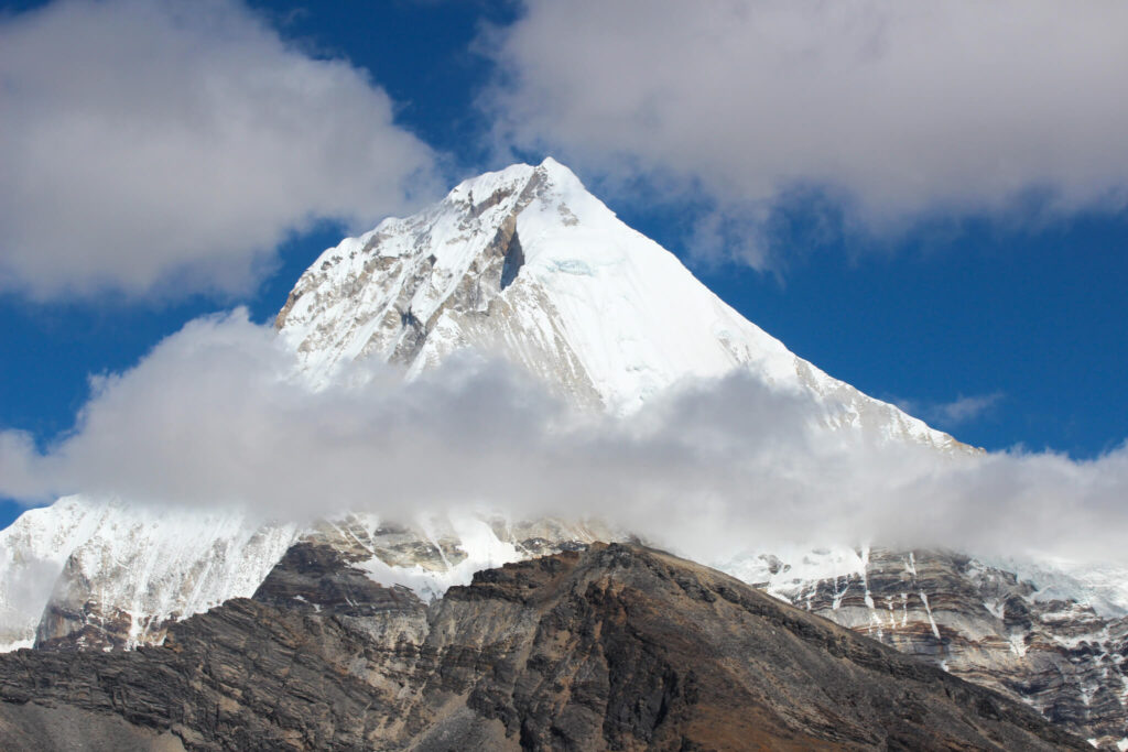
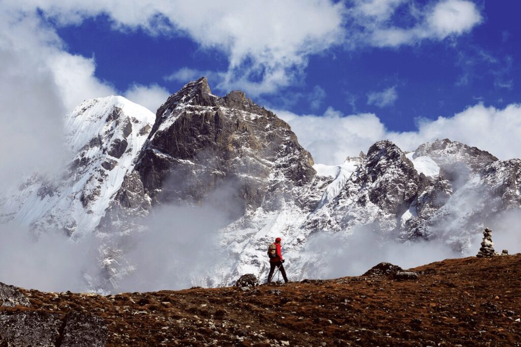
The Snowman Trek is often described as “the toughest trek in the world”. It is our longest and most challenging tour in Bhutan. It involves long trekking days, unpredictable weather, trekking in isolation and trekking in high mountain passes. But, despite the challenges, trekkers are rewarded with views of some of Bhutan’s most remote and stunning scenery. Starting outside Paro, the trek sweeps in a wide area along Bhutan’s northern border with Tibet, crossing the isolated Lunana plateau and further on to base of Mt Gangkar puensum and ino Bumthang province (central Bhutan).
Please note that this is a strenuous trek involving many long days of walking. It crosses several high mountain passes, most over 4000 meters and three mountain passes over 5000 meters. It is not for the faint-hearted. An excellent level of fitness, and previous high-altitude trekking experience, is needed.
The best time for the Snowman trek is the first three weeks of October, when the weather is perfect without wind or snow. And depending on the season, the camp may sometimes be on snow.
Group size: 6 – 10 people
Day 1: International arrival – Paro
Altitude in Paro: 2300 m / 7544 ft above sea level.
Paro is one of the most beautiful valleys in Bhutan and it is also the only gateway to Bhutan by air. Its administrative center, Rinpung Dzong, is one of the most sacred Dzongs of Bhutan, and in this beautiful valley you can find some of the earliest temples in the Kingdom such as the 7th century temple Kyichu Lhakhang, and Taktshang, also referred to as the Tiger’s Nest, built in the 17th century.
Paro sightseeing should always start with the visit to the National Museum housed in the Ta dzong (watch tower). The intriguing collection of artefacts serves as a great introduction to the rich culture and heritage of the Kingdom. The National Museum boasts a rich variety of exhibits collected from all over the country and belonging to different eras, some as early as 2000 B.C. A visit through the galleries shows the country’s transition from the later Stone Age to a modern Mahayana Buddhist kingdom.
Next, from the museum we will drive down to visit the Paro Dzong and take in the amazing architecture of this 17th century monument, a premier example of Bhutan’s architecture. Paro Dzong was built in 17th century to defend Paro from the Tibetan invasion. This fine example of Bhutanese architecture now serves as a central monastic and administrative seat of the Paro district.
From the Dzong, a leisurely walk back into Paro town crosses the scenic Nyamai Zampa, a unique model of Bhutan’s traditional cantilever bridge.
Next, visit the auspicious kyichu Monastery. The seventh century monastery is one of the oldest and most sacred temples in the Kingdom. The Tibetan King, Songsten Gampo ordered the establishment of monasteries in the Himalayan region to subdue evil spirits and to spread Buddhism. Of the 108 monasteries two were built in Bhutan namely the Kyichu Lhakhang and the Jampa Lhakhang in Bumthang.
Overnight in Paro.
Day 2: Paro.
Today’s exploration of Paro valley begins with an early hike to Taktsang Goemba (Tiger’s Nest monastery) 4-5 hrs. hike.
The monastery is one of Bhutan’s most revered monuments. It literally hangs off the face of a cliff 900 meters above the valley floor. The legend states that Guru Rinpoche flew into Paro valley on a mythical tigress and meditated in a cave where Taktsang stands today. The Taktshang Goempa is built around the cave. The hike offers spectacular views of the Goempa and the valley below. Horses or mules can be arranged on request to help lighten the journey.
After the visit we will drive up north to take a walk around the Drukgyel Dzong. The Dzong was built in 1649 to celebrate a decisive victory over Tibetan forces and to stop further invasions. Under the leadership of Zhabdrung, the Bhutanese fought twelve battles with the Tibetans in different parts of the country, whereof one took place in Drukgyel Dzong. In the later years, the Dzong became an administrative center under the Dzongpon (Lord of the Dzong) until gutted by a fire in 1951. Now it’s being rebuilt with financial help of Indian government.
Overnight in Paro.
Start of Trek.
Day 3: Drive Paro to Shana.
Trek Shana – Soi Thangthangkha.
Distance – 18 km.
Walking time – 6-7 hours.
Overnight Camp altitude – 3575 m above sea level.
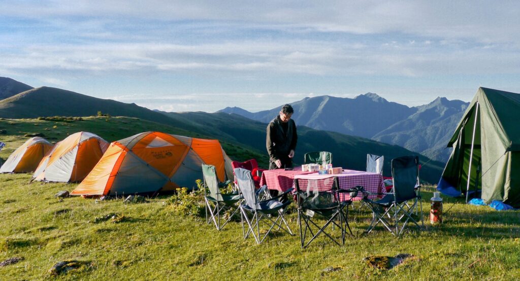
We will drive to Drukgyel Dzong, a ruined monastery, now under reconstruction, at the end of the Paro valley. From there, we follow a farm road, through a narrowing valley of rice fields, passing many traditional farmhouses along the way. We meet our trekking crew and packhorses near an army outpost, at an elevation of 2,890 meters.
From the army camp, we follow the Paro Chhu valley on an undulating, rocky, and sometimes muddy, trail. Bridges, adorned with prayer flags, cross the river in several places. At a fork in the trail, keep right: left leads to Tibet. After climbing gradually through a forest, with many short climbs and descents, we arrive at our campsite, in an open meadow. The summit of Mt Jhomolhari can be seen from the camp.
Day 4: Soi Thangthangkha – Jangothang.
Distance – 17 km.
Walking time – 5 – 6 hours.
Overnight Camp altitude – 4080 m above sea level.
The day starts with a gradual climb through alpine vegetation, until the landscape opens up into a wide high valley. We are surrounded by high ridges and snow-capped mountains all the way to Jangothang. We may come across yaks and yak herder camps and will pass through small clusters of houses.
Thirty to forty minutes after the village of Dangochang, which has a small school, we will arrive at Jangothang. This is Jhomolhri base camp, a flat meadow overlooked by the ruins of an ancient dzong. If the weather is clear, there are stunning views of Mt Jhomolhari and Jitchu Drake, both imposing snow-covered peaks.
We will relax at the campsite for the rest of the afternoon or visit the ruined dzong.
Day 5: Jangothang halt.
Overnight Camp altitude – 4080 m above sea level.
Today we will walk up the side valley, following the yak trails that weave along the valley slopes, to the base of Mt Jhomolhari. Climbing to the top of the moraine, we walk along a ridge, overlooking the glacier that snakes down from the mountain. The side-trip to see the glacier takes 5-6 hours return and we will have a picnic lunch on the way.
Day 6: Jangothang – Lingshi village.
Distance – 21 km.
Walking time – 7 – 8 hours.
Overnight Camp altitude – 4050 m above sea level.
Leaving Jhomolhari base camp, we begin with a short flat walk before a steep climb, into a high basin. We may see yaks and marmots along the way. The trail levels for a while, until the start of a long climb to the Nyile La pass, at 4890 meters. We pass a chorten, on a false summit, before the final ascent to the pass, where prayer flags flap in the wind.
From the pass, we descend, steeply at first, then follow the valley to a chorten, overlooking Lingshi dzong and the mountains beyond. From a rise just off the trail, we look over Mount Tserim Kang and its glaciers to the north. The descent to our campsite follows a switchback trail through low bushes to the valley bottom. We camp next to the river.
Day 7: Lingshi halt.
Distance – 18 km.
Walking time – 6-7 hours.
Overnight Camp altitude – 4050 m above sea level.
Today is a rest and acclimatisation day. You may choose to relax at the campsite or explore Lingshi village, which is a short climb out of the valley, on a steep trail, on the other side of the river. Not far from camp, up the valley, is Geu Goemba, a small temple tucked away on a cliff face, on the north side of the river.
Day 8: Lingshi – Chebisa.
Distance – 16 km.
Walking time – 5 – 6 hours.
Overnight Camp altitude – 3990 m above sea level.
It is a steep 45-minute climb from our camp to Lingshi dzong and the village of Lingshi. There is a Basic Health Unit and a school here.
From Lingshi, the trail meanders high along the side of the Mo Chhu valley, through alpine pastures. From a ridge at 4140 meters, we descend into a side-valley, to the village of Goyul, with a small temple, set into a rock face. Depending on timing, we may take lunch in a farmhouse in Goyul village. From there, we trek high along the valley to reach a small pass, from which the settlement of Chebsia and its impressive waterfall is visible. We camp tonight in Chebisa.
Day 9: Chebisa village to Shakyapasang.
Distance – 185km.
Walking time – 5 – 6 hours.
Overnight Camp altitude – 4000 m above sea level.
From Chebisa village we start the day with a steep 450-meter climb. We will cross the Gombu La pass at 4440 meters, from where there are spectacular views back towards Lingshi. The descent from the pass takes us down towards forested slopes to tonight’s camp by the river.
Day 10: Shakyapasang to Robluthang.
Distance – 16 km.
Walking time – 6-7 hours.
Overnight Camp altitude – 4160 m above sea level.
Today we have a climb of about 200 meters before the trail levels out for some time. Another short ascent brings us to the Jare La pass, at 4785 meters, marked by cairns and prayer flags. Several snow-clad peaks, including Tiger Mountain, Kang Bum and Jitchu Drake, are visible from the pass on a clear day.
From the pass we descend on a rocky trail next to a stream, before climbing into a side valley and a small lake. We will camp nearby.
Day 11: Robluthang to Limithang.
Distance – 14 km.
Walking time – 5 – 6 hours.
Overnight Camp altitude – 4140 m above sea level.
Today is a long day, with a steep climb to a high pass. We begin on a zig-zag trail that takes us up to a ridge at 4400 meters, with views over a wide glacial valley. Marmots are often seen popping up out of their burrows here. On the climb up to the pass, the Sinche La, at 5000 meters, noble rhubarb, a high-altitude Himalayan plant standing up to a meter tall, covers the hillside; a distraction from the final 300-meter ascent to the pass. Camp is in a cedar forest below the pass with a backdrop of Great Tiger Mountain.
Day 12: Limithang to Laya village.
Distance – 10 km.
Walking time – 4 hours.
Overnight Camp altitude – 3800 m above sea level.
We start with a walk through a forest, followed by a descent down to the river valley.
We then climb up to a ridge, from where we have views over Laya village, built on a shelving hillside, with Great Tiger Mountain in the background.
Day 13: Laya halt.
Overnight Camp altitude – 3800 m above sea level.
Today we will explore Laya village, rest and do some laundry. There may be a chance to take a traditional Bhutanese hot stone bath at a local farmhouse.
Laya has retained its own unique language and dress. The Layap women wear clothes woven from yak wool and a distinctive conical bamboo hat with a wooden pole protruding from the top.
Day 14: Laya village to Rodophu.
Distance – 16 km.
Walking time – 6-7 hours.
Overnight Camp altitude – 4215 m above sea level.
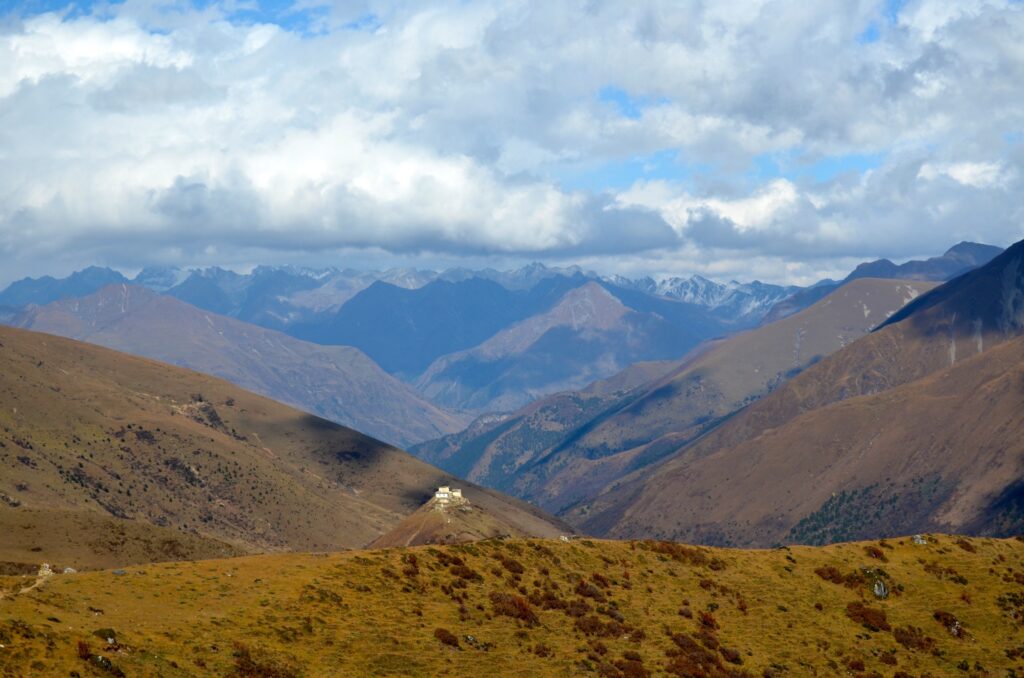
We say goodbye to the Layaps and make our way out of the village entry arch, through a stunning forest, following the valley of the Mo Chhu. It is a gradual descent to an army camp where we will have our trekking permits checked. About half an hour below the army camp, we turn east towards Lunana, on a narrow trail that leads steeply up through a forest. There are sweeping views along the Rodophu Chhu valley, from the undulating trail. There is a final climb before we descend to Rodophu, where we will camp near a stone shelter.
Day 15: Rodophu to Narethang.
Distance – 16 km.
Walking time – 6-7 hours.
Overnight Camp altitude – 4940 m above sea level.
Today’s walk follows the trail behind the Rodophu shelter towards a false pass. After about three hours, we will reach the Tsemo La pass 4905 meters.
This afternoon, we continue across a high, exposed plateau, reaching the campsite at Narethang, in the late afternoon. This is our first high camp, at 4940 meters, with the snowy peak of Gangla Karchung towering above us.
Day 16: Narethang to Tarina.
Distance – 16 km.
Walking time – 6-7 hours.
Overnight Camp altitude – 3940 m above sea level.
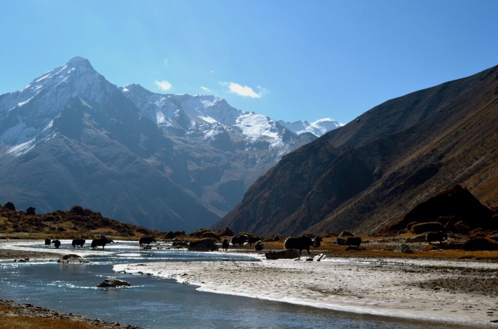
It is a short climb this morning to a high plateau and from there to the pass, the Karchung La 5220 meters. The pass affords stunning views across the Lunana plateau and a turquoise glacial lake below.
The trail descends steeply from the pass and then levels out as we follow the moraine. At the end of the moraine, the Tarina valley falls away to the north. There are spectacular views towards Teri Kang and its glaciers and glacial lakes.
A very steep descent, on a narrow, switch-back trail, takes us down into the Tarina Valley and a point where several streams meet, making the ground wet underfoot. We will continue along the valley bottom, past tall cliffs and beautiful waterfalls, to a flat camping place on the other side of the Tarina Chhu.
Day 17: Tarina to Woche.
Distance – 14 km.
Walking time – 4 – 5 hours.
Overnight Camp altitude – 4160 m above sea level.
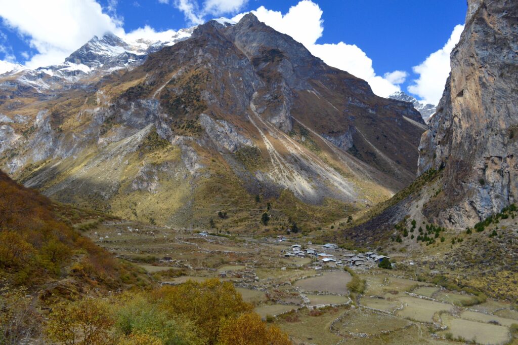
The trail continues along the valley bottom before climbing steeping through a dense forest to the village of Woche, the first settlement since leaving Laya and no more than a few stone farmhouses. We will have lunch near the village before the afternoon’s gentle walk down to the campsite, close to the Woche Chhu
Day 18: Woche to Lhedi.
Distance – 18 km.
Walking time – 4 hours.
Overnight Camp altitude – 3900 m above sea level.
From our campsite, we climb up past Green Lake to the Kesha La pass 4666 meters. on a zig-zag trail, through low shrubs. Prayer flags and cairns mark the pass.
From the pass, we descend on a steep, rocky switchback, through the small village of Tega. The snow-covered Table Mountain dominates the horizon. The trail continues parallel to the Pho Chhu, crossing a waterfall and dropping down to the riverbed. We cross and re-cross the numerous channels that wind through the valley, before a short but step climb on a muddy path to the village of Lhedi, where there is a school and Basic Health Unit.
Day 19: Lhedi to Thanza.
Distance – 17 km.
Walking time – 6-7 hours.
Overnight Camp altitude – 4100 m above sea level.
Today is the flattest walk of the trek. We leave the village of Lhedi, following the Pho Chhu, past the administrative buildings for the Lunana district.
We reach a wooden bridge across the river. The trail to the right leads to Thanza, and the mid-point of our trek, while left goes to the small village of Chozo. If time permits, we will make a detour to Chozo and visit Bhutan’s most isolated monastery. We then return to the bridge and continue along the east bank of the river, crossing flat yak pastures, until a chorten marks the entrance to Thanza.
Day 20: Thanza halt.
Overnight Camp altitude – 4100 m above sea level.
Thanza comprises several distinct settlements, watched over by the snow-covered 7000-meter Table Mountain. This morning is an opportunity to rest and relax in camp, in one of the most isolated valleys of the Himalayas.
In the afternoon, we may visit some of the local farmhouses or walk further up the valley to view one of the many glacial lakes in this area.
Day 21: Thanza to Zaram.
Distance – 22 km.
Walking time – 7 – 8 hours.
Overnight Camp altitude – 4870 m above sea level.
From Thanza, the trail climbs up a steep hillside to the top of a ridge. Looking back, we enjoy a panoramic view over the Thanza valley, Chozo and Table Mountain. We then turn into a side valley, where an impressive waterfall tumbles down a cliff face.
We will stop for lunch in a meadow, known as Djundje, which is surrounded by mountains. It is a long walk this afternoon, on an undulating trail, to tonight’s high campsite at Zaram, next to a river.
Day 22: Zaram to Minchugang.
Distance – 16 km.
Walking time – 6-7 hours.
Overnight Camp altitude – 4210 m above sea level.
After leaving camp, we begin the long climb to Tsorim Lake on a rocky trail. On a clear day, snow-capped peaks reflect in the waters of the lake.
From the lake, we climb to the highest pass of the trek, the Gophu La, at 5345 meters. We will add prayer flags to the many already strung between rocks and cairns, as we give thanks for our safe arrival at the pass.
From here we descend, over a moraine and across a rocky plateau to the ruins of a yak herders’ camp, known as Minchugang.
Day 23: Minchugang to Uruthang.
Distance – 12 km.
Walking time – 4 – 5 hours.
Overnight Camp altitude – 4455 m above sea level.
Today is one of the most challenging days of the trek, with three passes to cross. We will start early, following a trail high above the Sasha Chhu, before a steep climb to the Phrodrang La 4652 meters.
From here, we descend, before another steep, rocky climb to the 4820-meter Saga La. On the approach to the Saga La, we pass by a stone hut built on to the side of a large boulder, with a lake below. When we reach the pass, we will be rewarded with panoramic views over snow-capped peaks and sweeping valleys, making all the effort worthwhile.
The descent from the Saga La is a welcome relief from the day’s climbing and the third pass, the Uruthang La, is a much gentler ascent. From there we will walk for another hour to an hour and a half, across a swampy meadow, before a short climb to a yak herder’s hut which marks the campsite at Uruthang.
Day 24: Uruthang to Dur Tsachu.
Distance – 10 km.
Walking time – 4 hours.
Overnight Camp altitude – 3300 m above sea level.
From Uruthang, we have a short climb to the only pass of the day, the Nephu La 4495 meters, with its single cairn. Then, it’s all downhill, through alpine meadows, passing a lake, called Animo Tsho, in which a nun is said to have drowned. We may see blue sheep on the high crags above us.
We descend below the tree line, following a stream through forest and rhododendrons. By lunch time we have reached a waterfall. We then continue along winding trails before crossing the river on a wooden bridge and beginning the climb up to Dur.
Dur hot springs comprise a series of simple wooden bathing huts built around natural hot springs of varying temperatures. After our many days in the mountains, bathing in the hot springs is bliss. We camp tonight next to the river.
Day 25: Dur Tsachu to Tshochenchen.
Distance – 16 km.
Walking time – 6-7 hours.
Overnight Camp altitude – 3920 m above sea level.
Although we are nearing the end of the trek, today’s walk involves a relentless, steep ascent of more than 1000 meters. We set off from the hot springs, past a yak herder’s hut in a clearing, before climbing through a forest to the Gongto La pass at 4327 meters. After the pass, we walk along the shore of lake Djule Tsho before climbing again to the Jule La, our final pass of the trek, from where there are spectacular views. At 4550 meters, we will have climbed 1250 meters from our camp the previous night.
From the Jule La, we descend 600 meters, through yak pasture, to a wide river valley. We cross the river on a narrow wooden bridge to our last campsite at Tshochenchen.
Day 26: Tshochenchen to Jakar (Bumthang).
Distance – 25 km.
Walking time – 8-9 hours.
Altitude in Bumthang: 2800 m / 9186 ft above sea level.
We finish the trek with a long walk, on a rocky and often muddy trail. There are several river crossings and short ascents and descents through the forest, before we begin the long descent to the Bumthang valley and the end of our trek. We finish by crossing the river on a suspension village and arrive in the small village of Mechugang. We will say farewell to our horsemen and crew here before the short drive to our hotel in the Bumthang valley.
End of Trek.
Overnight in Bumthang.
Day 27: Bumthang.
Altitude in Bumthang: 2800 m / 9186 ft above sea level.
Bumthang is the most eastern point of your pilgrimage through the Land of the Thunder Dragon. It is considered by the Bhutanese as the spiritual hub of the country.
Temple Tour:
Jampa monastery is believed to have been built in the year 659 by the Tibetan King Songtsen Gampo, on the same day as Kyichu Lhakhang in Paro, in order to subdue a Tibetan demoness. It was here that Guru Rinpoche conducted the first sermon on Tantric Buddhism for his host King Sindhu Raja, the local ruler and his family.
Kurjey monastery is named after the body (kur) print (jey) of Guru Rinpoche who was invited to meditate here in 746 A.D to subdue evil spirits and demons. There are three temples; the oldest temple was built in 1652 on the rock face where Guru Rinpoche meditated. The body imprint of the great master can be seen distinctly in the rock cave enshrined in the temple. The second was built in 1900 by the first King when he was still the Governor of Trongsa. The third temple was built in 1990 with the support of the Royal grandmother Ashi Kesang. A wall of 108 chortens surrounds the temple grounds and symbolizes Buddha’s victory over the evil spirits. The Cypress tree which is seen near the temple is believed to have grown from the Guru’s walking stick.
From there we will continue by crossing a newly constructed bridge to the other side of the valley to Dorjebee village for Typical farm house lunch experience. The family has cooked for the Royal family for generations. There the food is not just traditional Bhutanese food but serves Bumthang specialties made from local products such as buckwheat. By the time, you arrive at their house, the lady of the house will have spent the entire afternoon preparing a range of local dishes, including some of the Royal family’s favorites for you to enjoy along with a taste of their home-made local wine (ara).
Tamshing monastery (temple of good message) The monastery is located in a village across the river from Kurjey. It was built by Pema Lingpa in 1501 and is the most important Nyingma monastery in the Kingdom. Being a skilled tantric master and an artist, Pema Lingpa sculpted the main statues and painted the frescoes, which can be seen even today, mostly in original state. He also created a 25-kg suit of chain-mail armor and it is believed that you will be freed from your sins if you carry it around the monastery three times.
Overnight in Bumthang.
Day 28: Transfer to Phobjikha valley.
Distance: 160 km
Driving time: 6 hrs drive.
Altitude in Thimphu: 2900 m / 9514 ft above sea level.
Phobjikha Valley is one of the most stunning areas in the country. The wide flat valley without any trees after the hard climb through dense forest is an extremely rare experience in Bhutan. In contrast to some parts of Bhutan, where modern development is already very apparent, Phobjikha is a place with natural beauty, untouched scenery, local traditions and culture, and unconstrained peacefulness.
Today our pilgrimage takes us back towards west Bhutan following the only east west highway over Yotong la Pass into Trongsa valley. There briefly visit the Trongsa Museum housed in the Ta Dzong (watch tower). This watch tower on the hill above the Dzong has been converted in to a state of art museum in 2008.
Visit also the Trongsa Dzong. This commanding Dzong is perhaps the biggest and the most spectacular sited Dzong in Bhutan. The Dzong’s strategic location gave it great power over this part of the country. It is the ancestral home of Bhutan’s royal family. The first two hereditary kings ruled from this dzong.
After the visit, continue driving through the alpine forest of fir, juniper, hemlock and rhododendron. On the way briefly visit Chendebje Chorten. The chorten is at a lovely spot by the river side. Built in 19th century by a lama from Tibet to cover the remains of an evil spirit. Chendbji is considered as boundary between eastern and western Bhutan.
The journey continues over Pelela pass and winding into glacier valley of Phobjikha filled with dwarf bamboos. The valley is one of the most important wildlife preserve in the country, because of the large flock of black necked cranes that migrates from Tibet in the winter.
Overnight in Phobjikha.
Day 29: Transfer to Punakha.
Distance: 87 km
Driving time: 3 hrs drive.
Altitude in Punakha: 1300 m / 4264 ft above sea level.
The sub-tropical valleys of Punakha and the surrounding mountain sides offer a large variety of attractive places to explore and discover monasteries and the most impressive Dzong in the country.
Today before driving to Punakha, we will visit the Crane education center. There we can watch the short documentary on the magnificent black necked crane and also look out for the cranes in the valley with the help of a binocular there.
Next, we will briefly visit the famous 16th century Gangtey Goemba that overlooks the large green expanse of the valley. The monastery is surrounded by a large village inhabited mainly be the families of the Gomchens (lay monk) who take care of the monastery.
After two hours of descend we will arrive Wangdiphodrang valley. There we will visit the Wangdiphodrang Dzong which was burnt down by fire in 2012. We will continue the drive to Punakha valley. There we will visit the stunning Punakha Dzong. It was the seat of the government every winter until Thimphu was established as the permanent capital in 1955. Take time to admire the impressive, colorful and detailed artistry of the surroundings, including paintings of one-thousand Buddha.
Next, we will drive up the valley north and cross the Mo Chhu to hike up and pay respect to the grand Khamsum Yuelley Namgyal Chorten. forces and to provide peace, stability, and harmony in an ever- changing world. It is therefore filled with every form of colorful protector imaginable. The Chorten is 30 meters tall and can be seen in the distance when driving. The three-leveled chorten is built to remove negative forces and to provide peace, stability, and harmony in an ever- changing world. It is therefore filled with every form of colorful protector imaginable.
Overnight in Punakha.
Day 30: Transfer to Thimphu.
Distance: 71 km
Driving time: 2 hrs 30 mins drive.
Altitude in Thimphu: 2400 m / 7874 ft above sea level.
Our pilgrimage begins with a journey towards east into the booming metropolis of Thimphu. Situated at an altitude of 2400 m it is home to 140,000 Bhutanese. Thimphu being the capital of Bhutan, offers unique opportunities to explore the Bhutanese culture, lifestyle and traditions in depth.
In two hours’ drive we will we reach the Dochula pass, 3030 m. There if weather permits, we will be able to see the extended eastern Himalayas in Bhutan.
We will briefly visit the Dochula monastery and continue our journey to the capital city Thimphu.
There we will spend our time circumambulating the sacred National Memorial Chorten. This is a Tibetan-style chorten built in 1974 in memory of the late King Jigme Dorji Wangchuk who passed away in 1972. It is one of the most visible religious structures in town and for many people it is the focus of daily worship. Remember to walk around the Chorten at least once to gain merit and good luck.
Next, we will drive up a ridge to visit the Biggest Buddha Statue at Kunesel Phodrang in Thimphu. This statue of Buddha measures 52 meters. It is one of the largest statues in the world. The statue is made of bronze and is gilded in gold. There are many smaller Buddha statues placed inside.
We will also browse the striking collection of intricate textiles at the National Textile museum.
The Museum introduces you to the living national art of weaving. The exhibition displays the major weaving techniques and styles of local dress and textile made by the Bhutanese women and men.
In the evening you can stroll in the town, visit the Local Craft market just above the Textile museum and visit local handicraft shops.
The last day spend at the capital city is a great way to end and your journey to this ancient kingdom of BHUTAN.
Overnight in Thimphu.
Day 31: Transfer to Paro – International departure to your onward journey.


Leave a Reply
Your email is safe with us.