

This Laya Gasa trek with cultural tour Glimpse of Bhutan is designed to give our visitors not only wild nature experience but also an insight into the rural live of Bhutan, where subsistence farming is still practiced.
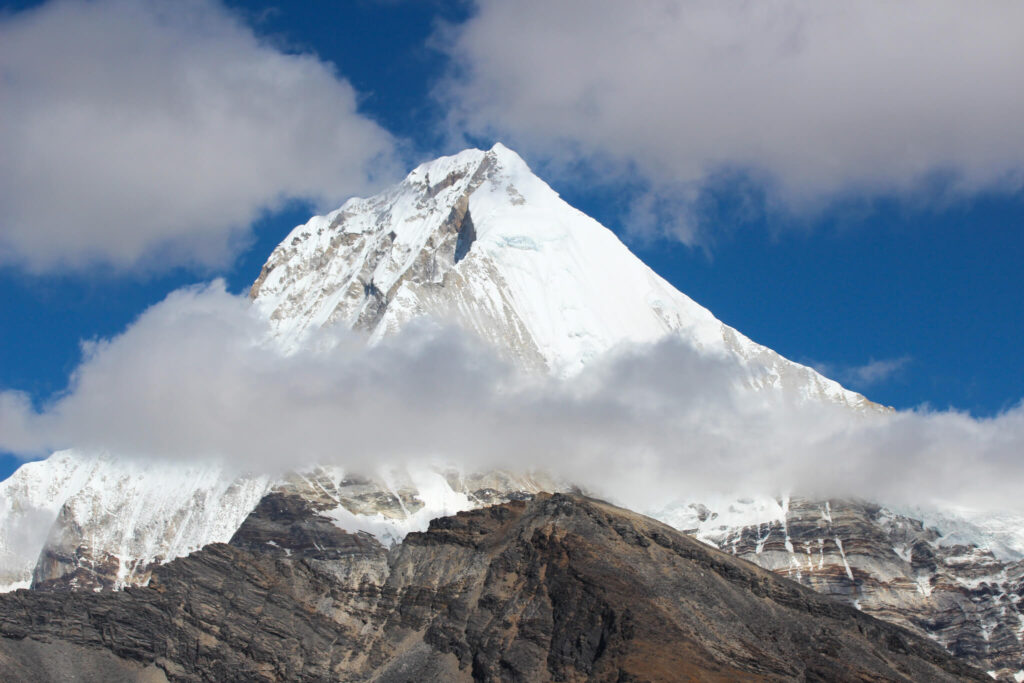
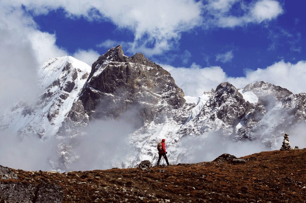
The Laya Gasa trek is one of the most strenuous treks in Bhutan. This trekking trail will take you through the most picturesque places with altitude differences between 2500 m – 5000 m above sea level. While on the trek you will travel through scenic isolated mountains, villages and you will indulge into Bhutan’s pristine nature. You will also, have the spectacular view of the sacred mountain Jhomlhari, Jichu Drake and Gangchenta.
You will also travel through the village of laya and come in contact with the layapa (semi Nomadic) yak herders. They have unique culture, language and dress. From Laya the trek route then turns south, finishing at Gasa, in the Punakha Valley.
Please note that this trek involves some long days of walking and crosses several high passes. A good level of fitness is essential.
Day 1: International arrival – Paro
Altitude in Paro: 2300 m / 7544 ft above sea level.
Paro is one of the most beautiful valleys in Bhutan and it is also the only gateway to Bhutan by air. Its administrative center, Rinpung Dzong, is one of the most sacred Dzongs of Bhutan, and in this beautiful valley you can find some of the earliest temples in the Kingdom such as the 7th century temple Kyichu Lhakhang, and Taktshang, also referred to as the Tiger’s Nest, built in the 17th century.
Paro sightseeing should always start with the visit to the National Museum housed in the Ta dzong (watch tower). The intriguing collection of artefacts serves as a great introduction to the rich culture and heritage of the Kingdom. The National Museum boasts a rich variety of exhibits collected from all over the country and belonging to different eras, some as early as 2000 B.C. A visit through the galleries shows the country’s transition from the later Stone Age to a modern Mahayana Buddhist kingdom.
Next, from the museum we will drive down to visit the Paro Dzong and take in the amazing architecture of this 17th century monument, a premier example of Bhutan’s architecture. Paro Dzong was built in 17th century to defend Paro from the Tibetan invasion. This fine example of Bhutanese architecture now serves as a central monastic and administrative seat of the Paro district.
From the Dzong, a leisurely walk back into Paro town crosses the scenic Nyamai Zampa, a unique model of Bhutan’s traditional cantilever bridge.
Next, visit the auspicious Kyichu Monastery. The seventh century monastery is one of the oldest and most sacred temples in the Kingdom. The Tibetan King, Songsten Gampo ordered the establishment of monasteries in the Himalayan region to subdue evil spirits and to spread Buddhism. Of the 108 monasteries two were built in Bhutan namely the Kyichu Lhakhang and the Jampa Lhakhang in Bumthang.
After the visit we will drive up north to take a walk around the Drukgyel Dzong. The Dzong was built in 1649 to celebrate a decisive victory over Tibetan forces and to stop further invasions. Under the leadership of Zhabdrung, the Bhutanese fought twelve battles with the Tibetans in different parts of the country, whereof one took place in Drukgyel Dzong. In the later years, the Dzong became an administrative center under the Dzongpon (Lord of the Dzong) until gutted by a fire in 1951. Now it’s being rebuilt with financial help of Indian government.
Overnight in Paro.
Day 2: Paro.
Today’s exploration of Paro valley begins with an early hike to Taktsang Goemba (Tiger’s Nest monastery) 4-5 hrs. hike.
The monastery is one of Bhutan’s most revered monuments. It literally hangs off the face of a cliff 900 meters above the valley floor. The legend states that Guru Rinpoche flew into Paro valley on a mythical tigress and meditated in a cave where Taktsang stands today. The Taktshang Goempa is built around the cave. The hike offers spectacular views of the Goempa and the valley below. Horses or mules can be arranged on request to help lighten the journey.
Lunch at Farm House followed by Traditional Hot stone Bath which will help easy your muscle pain from the climb.
Towards evening we will stroll around Paro Town is a must for all visitors who come to this valley. The town dates back from 1985 and its lined up by souvenir shops and café. If you are in for a good cup of café, stop at Mountain Café Roastery. They serve the best coffee in Bhutan.
Overnight in Paro.
Start of Trek.
Day 3: Paro to Shana.
Trek Shana – Soe Thangthangkha.
Distance – 18 km
Walking time – 6-7 hours.
Overnight Camp altitude 4040 m / 13250 fts above sea level.
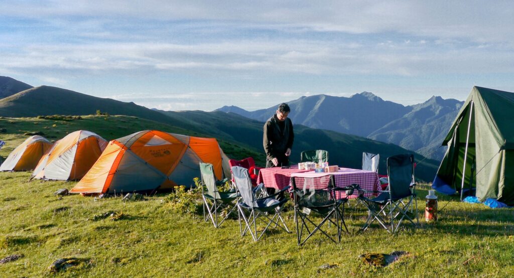
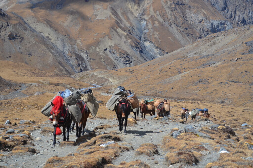
We will drive to Drukgyel Dzong, at the end of the Paro valley and then on a farm road through a narrowing valley of paddy fields, passing many traditional farmhouses along the way. We will start the trek at an army outpost at an elevation of 2890 m, after meeting our horses and trekking crew. At the start of the trek the staff always takes some time to get organized.
From the army camp, we set off uphill following the river and through the valley, which gradually narrows and closes in. The trail forks, with the left-hand track leading to Tibet. We stay on the right, flowing the trail past a large chorten, not far from our first night’s camp. The campsite is located in a meadow with a stone shelter, from where the summit of Mt Jhomolhari is visible on a clear day.
Day 4: Soi Thangthangkha – Jangothang.
Distance – 17 km.
Walking time – 5-6 hours.
Overnight Camp altitude 4,100 m / 13448 fts above sea level.
The day starts with a gradual climb as the vegetation turns alpine, until the landscape opens up into a wide high valley. We pass by another army camp, where our trekking permit will be checked. We are surrounded by high ridges and snow-capped mountains all the way to Jangothang. We may come across yaks and yak herder camps. At the village of Dangojang, there is a small school with about a dozen students and another forty minutes brings us to Jhomolhari Base Camp, known as Jangothang.
From Jangothang, there are stunning views of Mt Jhomolhari and Jitchu Drake, both imposing snow-covered peaks. The campsite is overlooked by the ruins of an ancient dzong.
Day 5: Jangothang halt.
Today is an acclimatization day. Many yak trails weave along the sides of the valley that leads to the base of Mt Jhomolhari. We will climb up the moraine to a ridge overlooking the glacier that snakes down from the mountain. The hike up the valley to see the glacier takes 5-6 hours return and we will have a picnic lunch on the way.
Day 6: Jangothang – Lingshi village
Distance – 19 km.
Walking time – 7 – 8 hours.
Overnight Camp altitude 4150 m / 13612 fts above sea level.
Today, we have a steep climb into a high basin, from where the trail levels for a while, until the start of a long climb to the Nyile La pass at 4,890m. After the pass, from where there are stunning views, there is an easy descent into Lingshi basin. The vegetation is sparse and, as we approach Lingshi, there is a wide panorama across to Lingshi dzong, Mount Tserim Kang and its glaciers to the north. We camp next to the river in the valley bottom.
Day 7: Lingshi village – Chebisa village.
Distance – 12 km.
Walking time – 5 – 6 hours.
Overnight Camp altitude 3990 m / 13,087 above sea level.
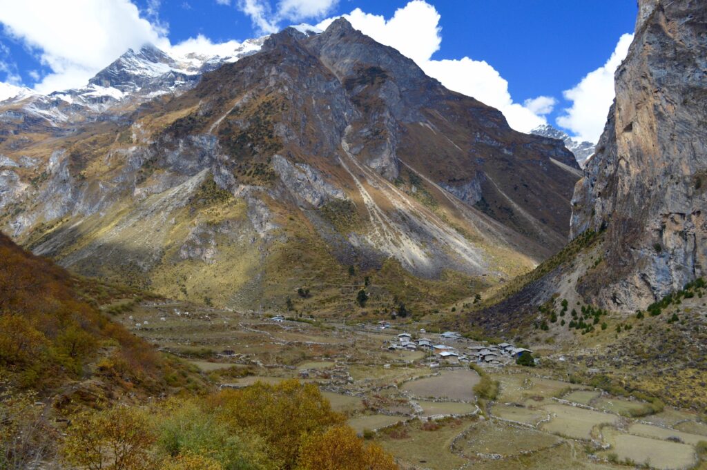
It is a steep 45-minute climb from our camp next to the river to Lingshi dzong and the village of Lingshi where we will wander through the village. There is a Basic Health Unit and a school here. From Lingshi, the trail meanders high along the valley sides, through alpine pastures where we may see the elusive Himalayan blue sheep. We pass the village of Goyul and an ancient dzong. Depending on our timing, we may take lunch in a farmhouse in Goyul village. Trekking high above the valley, we reach a small pass from which the settlement of Chebsia is visible.
Day 8: Chebisa village to Shakyapasang.
Distance – 18 km.
Walking time – 6-7 hours.
Overnight Camp altitude 4000 m / 13120 fts above sea level.
From Chebisa village we start the day with a steep 450 m climb. We will cross the Gombu La pass at 4440 m, from where there are spectacular views back towards Lingshi. The descent from the pass takes us down towards forested slopes to tonight’s camp by the river.
Day 9: Shakyapasang to Robluthang.
Distance – 16 km.
Walking time – 7-8 hours.
Overnight Camp altitude 4160 m / 13644 fts above sea level.
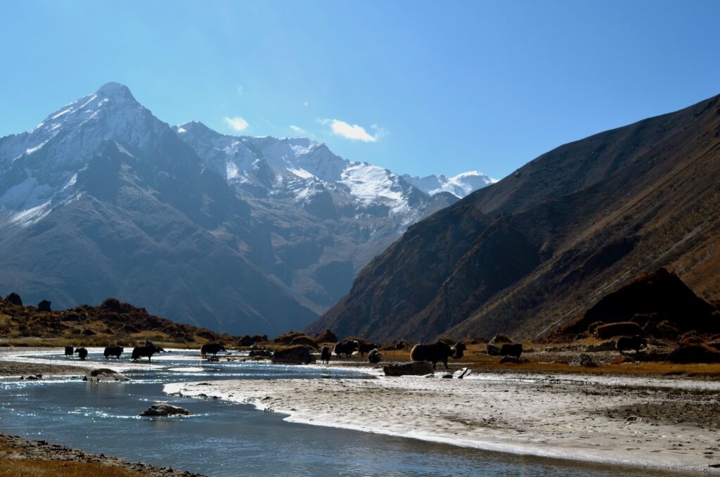
Today we have a climb of about 200m before the trail levels out for some time. Another short ascent to the Jare La pass brings us to 4,785 m, about three hours after leaving last night’s camp. Several snow-clad peaks are visible from the pass on a clear day. This is prime yak-grazing land and we may see herds of yaks on our way to camp in the valley floor.
Day 10: Robluthang to Limithang.
Distance – 15 km.
Walking time – 6-7 hours.
Overnight Camp altitude 4160 m /13644 fts above sea level.
A zig-zag trail takes us up to a ridge at 4,400m, with views over a wide glacial valley. Marmots abound in this area and are often seen popping up out of their burrows. On the climb up to the highest pass of the trek, the Sinche La, at 5,000 m, noble rhubarb, a high-altitude Himalayan plant standing up to a metre tall, covers the hillside; a distraction from the final 300 m ascent to the pass. Camp is in a cedar forest below the pass with a backdrop of Great Tiger Mountain.
Day 11: Limithang to Laya village.
Distance – 10 km.
Walking time – 4 hours.
Overnight Camp altitude 3800 m / 12464 fts above sea level.
We start with a walk through a forest, followed by a descent down to the river valley. With a shorter distance to cover today, we should arrive in Laya village with time to explore. Laya has retained its own unique language and dress, with the Layap women wearing a distinctive conical bamboo hat with a wooden pole protruding from the top.
Day 12: Halt at Laya Village.
Today we will explore Laya village and meet with the locals there and learn about their way of life. The women are responsible to look after the yaks and men are often on trading missions.
Overnight Camp altitude 3800 m above sea level.
Day 13: Laya village to Koina – Gasa Hot Spring.
Distance – 17 km.
Walking time – 6 hours.
Overnight Camp altitude 3240 m / 10627 fts above sea level.
We say goodbye to the Layaps and make our way out of the village through a stunning forest, past an army camp, following the river valley. We have a series of climbs up and over spurs above the river. On the way we will visit the Gasa dzong. It was built By Zhabdrung in 1646. The local call it as Tashi Thonhmon Dzong. The Dzong has a distinctive structure with a circular shape and has three watch towers standing at strategic points.
Today we will camp next to Gasa Tshachu (Gasa Hot spring).
Hot springs are known as Tshachus and are found all over the Kingdom. The medicinal properties of these hot springs have been used by the Bhutanese people for centuries to cure various ailments ranging from arthritis to body aches and even sinuses. It is a popular tradition among Bhutanese to visit hot springs during the winter months.
The hot spring at Gasa is situated close to the banks of the Mo Chu River in Punakha. This is one of the most popular springs in the country and are frequented with local people. Bathing facilities have also been provided to ensure that the Hot Springs remain clean and hygienic.
End of Trek.
Overnight in Gasa.
Day 14: Transfer to Punakha.
Distance: 47 kms
Driving time: 1 hr 30 mins drive.
Altitude in Punakha: 1300 m / 4264 ft above sea level.
The sub-tropical valleys of Punakha and the surrounding mountain sides offer a large variety of attractive places to explore and discover monasteries and the most impressive Dzong in the country.
Today we will drive to Punakha. On the way we will hike up and pay respect to the grand Khamsum Yuelley Namgyal Chorten. The Chorten is 30 meters (100 feet) tall and can be seen in the distance when driving. The three-leveled chorten took eight and a half years to build and was consecrated in 1999. Dedicated to the Fifth King, it was built to remove negative forces and to provide peace, stability, and harmony in an ever- changing world. It is therefore filled with every form of colorful protector imaginable.
After lunch we will drive down to visit the stunning Punakha Dzong.
The Dzong is considered one of the most important and also one of the most beautiful Dzongs in the Kingdom. It was built by Zhabdrung Ngawang Namgyel in 1637, and was the seat of the government every winter until Thimphu was established as the permanent capital in 1955. It is still the winter residence of the Dratshang (Central Monastic Body). Take time to admire the impressive, colourful and detailed artistry of the surroundings, including huge statues of Buddha, Guru Rinpoche and Zhabdrung Ngawang Namgyel, as well as paintings of one-thousand Buddhas.
Overnight in Punakha.
Day 15: Transfer to Thimphu.
Distance: 71 kms
Driving time: 2 hrs 30 mins drive.
Altitude in Thimphu: 2400 m / 7874 ft above sea level.
Our pilgrimage begins with a journey towards east into the booming metropolis of Thimphu. Situated at an altitude of 2400 m it is home to 140,000 Bhutanese. Thimphu being the capital of Bhutan, offers unique opportunities to explore the Bhutanese culture, lifestyle and traditions in depth.
On our way to Thimphu, roughly 15 minutes’ drive from the hotel we will stop to hike to the famous Chimi Lhakhang (Fertility temple). The 30-minute walk from the road to the lhakhang is through open farmland. It is believed that a demoness who had been terrorizing the valley transformed herself into a black dog to escape the wrath of Drukpa Kuenlay, the Divine Madman. However, he caught the dog and buried it under a pile of earth shaped like a woman’s breast. He then built a chorten on top of this mount and prophesied that a temple would one day be consecrated over it. True to the prophecy, his brother, Lam Ngawang Chogyal, built Chime Lhakhang in 1456. If you are wishing for a child, it is believed by the Bhutanese that a visit to Chime Lhakhang, might help increase your chances! Hundreds of couples visit the lhakhang to pray to become pregnant and receive a wang (blessing). Many parents also bring their newborn children to receive the baby’s name from the local lama.
After the hike we will drive up the mountain for 2 hrs until we reach the Dochula pass (3000 m). There if weather permits, we will be able to see the extended eastern himalayas in Bhutan. We will have our lunch at the cafeteria visit the Dochula monastery and continue our journey to the capital city Thimphu.
We invite you to see the sights of the Kingdom’s capital with us. Below we have listed some of the experiences that we enjoy the most!
We will briefly visit Semtokha Dzong. The oldest dzong in the country (built in 1629) stands on a soaring ridge 5 km away from Thimphu. Its strategic position is evident as it controls all the approaches to and from Thimphu. Notice the contrast of traditional and modern as you enter the dzong grounds; the white painted dzong with the growing city in the background and the newly constructed 52 m tall Buddha statue perched on the hill right behind.
Overnight in Thimphu.
Day 16: Thimphu.
After breakfast we will spend our time circumambulating the sacred National Memorial Chorten. This is a Tibetan-style chorten built in 1974 in memory of the late King Jigme Dorji Wangchuk who passed away in 1972. It is one of the most visible religious structures in town and for many people it is the focus of daily worship. Remember to walk around the Chorten at least once to gain merit and good luck.
Next, we will drive up a ridge to visit the Biggest Buddha Statue at Kunesel Phodrang in Thimphu. This statue of Buddha measures 52 meters. It is one of the largest statues in the world. The statue is made of bronze and is gilded in gold. There are many smaller Buddha statues placed inside.
We will drive to the National Post Office for stamps. Bhutan is famous for producing unique and innovative stamps. After selling peculiar ‘CD-stamps’ Bhutan’s Post office now offers personalized stamps; we invite you to surprise your family and friends with your custom-made stamp made with one of your favorite holiday photographs!
Next, we will take in more of kingdom’s rich culture at the Folk Heritage Museum. The museum is a restored three story traditional rammed mud and timber house inaugurated as a museum by Her Majesty the Queen Ashi Dorji Wangmo Wangchuk in 2001. It showcases the traditional artifacts used now and, in the past, which helps connect people to the Bhutanese rural life.
Typical Bhutanese Lunch at the Museum restaurant.
After lunch visit the Bhutanese Paper Factory. The art of handmade paper in Bhutan dates back to the 8th century, although usage was limited mainly to religious purposes. Today it is considered an important element in the preservation of Bhutan’s cultural heritage. The factory allows guests to view the paper making process and purchase gifts from their show room.
We will also browse the striking collection of intricate textiles at the National Textile museum.
The Museum introduces you to the living national art of weaving. The exhibition displays the major weaving techniques and styles of local dress and textile made by the Bhutanese women and men.
In the evening you can stroll in the town, visit the Local Craft market just above the Textile museum and visit local handicraft shops.
The last day spend at the capital city is a great way to end and your journey to this ancient kingdom of BHUTAN.
Overnight in Thimphu.
Day 17: Transfer to Paro – International departure to your onward journey.


Leave a Reply
Your email is safe with us.