Day 1: International arrival – Paro
Altitude in Paro: 2300 m / 7544 ft above sea level.
Paro is one of the most beautiful valleys in Bhutan and it is also the only gateway to Bhutan by air. Its administrative center, Rinpung Dzong, is one of the most sacred Dzongs of Bhutan, and in this beautiful valley you can find some of the earliest temples in the Kingdom such as the 7th century temple Kyichu Lhakhang, and Taktshang, also referred to as the Tiger’s Nest, built in the 17th century.
Paro sightseeing should always start with the visit to the National Museum housed in the Ta dzong (watch tower). The intriguing collection of artefacts serves as a great introduction to the rich culture and heritage of the Kingdom. The National Museum boasts a rich variety of exhibits collected from all over the country and belonging to different eras, some as early as 2000 B.C. A visit through the galleries shows the country’s transition from the later Stone Age to a modern Mahayana Buddhist kingdom.
Next, from the museum we will drive down to visit the Paro Dzong and take in the amazing architecture of this 17th century monument, a premier example of Bhutan’s architecture. Paro Dzong was built in 17th century to defend Paro from the Tibetan invasion. This fine example of Bhutanese architecture now serves as a central monastic and administrative seat of the Paro district.
From the Dzong, a leisurely walk back into Paro town crosses the scenic Nyamai Zampa, a unique model of Bhutan’s traditional cantilever bridge.
Next, visit the auspicious kyichu Monastery. The seventh century monastery is one of the oldest and most sacred temples in the Kingdom. The Tibetan King, Songsten Gampo ordered the establishment of monasteries in the Himalayan region to subdue evil spirits and to spread Buddhism. Of the 108 monasteries two were built in Bhutan namely the Kyichu Lhakhang and the Jampa Lhakhang in Bumthang.
After the visit we will drive up north to take a walk around the Drukgyel Dzong. The Dzong was built in 1649 to celebrate a decisive victory over Tibetan forces and to stop further invasions. Under the leadership of Zhabdrung, the Bhutanese fought twelve battles with the Tibetans in different parts of the country, whereof one took place in Drukgyel Dzong. In the later years, the Dzong became an administrative center under the Dzongpon (Lord of the Dzong) until gutted by a fire in 1951. Now it’s being rebuilt with financial help of Indian government.
Overnight in Paro.
Day 2: Paro.
Today’s exploration of Paro valley begins with an early hike to Taktsang Goemba (Tiger’s Nest monastery) 4-5 hrs. hike. The monastery is one of Bhutan’s most revered monuments. It literally hangs off the face of a cliff 900 meters above the valley floor. The legend states that Guru Rinpoche flew into Paro valley on a mythical tigress and meditated in a cave where Taktsang stands today. The Taktshang Goempa is built around the cave. The hike offers spectacular views of the Goempa and the valley below. Horses or mules can be arranged on request to help lighten the journey.
In the afternoon you can take a stroll in the town. The town dates back from 1985 and its lined up by souvenir shops and café. If you are in for a good cup of café, stop at Mountain Café Roastery. They serve the best coffee in Bhutan.
Overnight in Paro.
Start of Trek.
Day 3: Drive Paro to Shana.
Trek Shana – Soi Thangthangkha.
Distance – 16 km.
Walking time – 6-7 hours.
Overnight Camp altitude 3575 m / 11726 fts above sea level.
We will drive to Drukgyel Dzong, a ruined monastery, now under reconstruction, at the end of the Paro valley. From there, we follow a farm road, through a narrowing valley of rice fields, passing many traditional farmhouses along the way. We meet our trekking crew and packhorses near an army outpost, at an elevation of 2890 meters. From the army camp, we follow the Paro Chhu valley on an undulating trail. Bridges, adorned with prayer flags, cross the river in several places. At a fork in the trail, keep right: left leads to Tibet. The rest of the day’s walk climbs gradually up through a dense forest. Just after a big chorten, we catch our first glimpse of Mt Jomolhari. Not far from here, the campsite is located in a clearing.
Day 4: Soi Thangthangkha – Jangothang.
Distance – 14km.
Walking time – 5-6 hour.
Overnight Camp altitude 4040 m / 13250 fts above sea level.
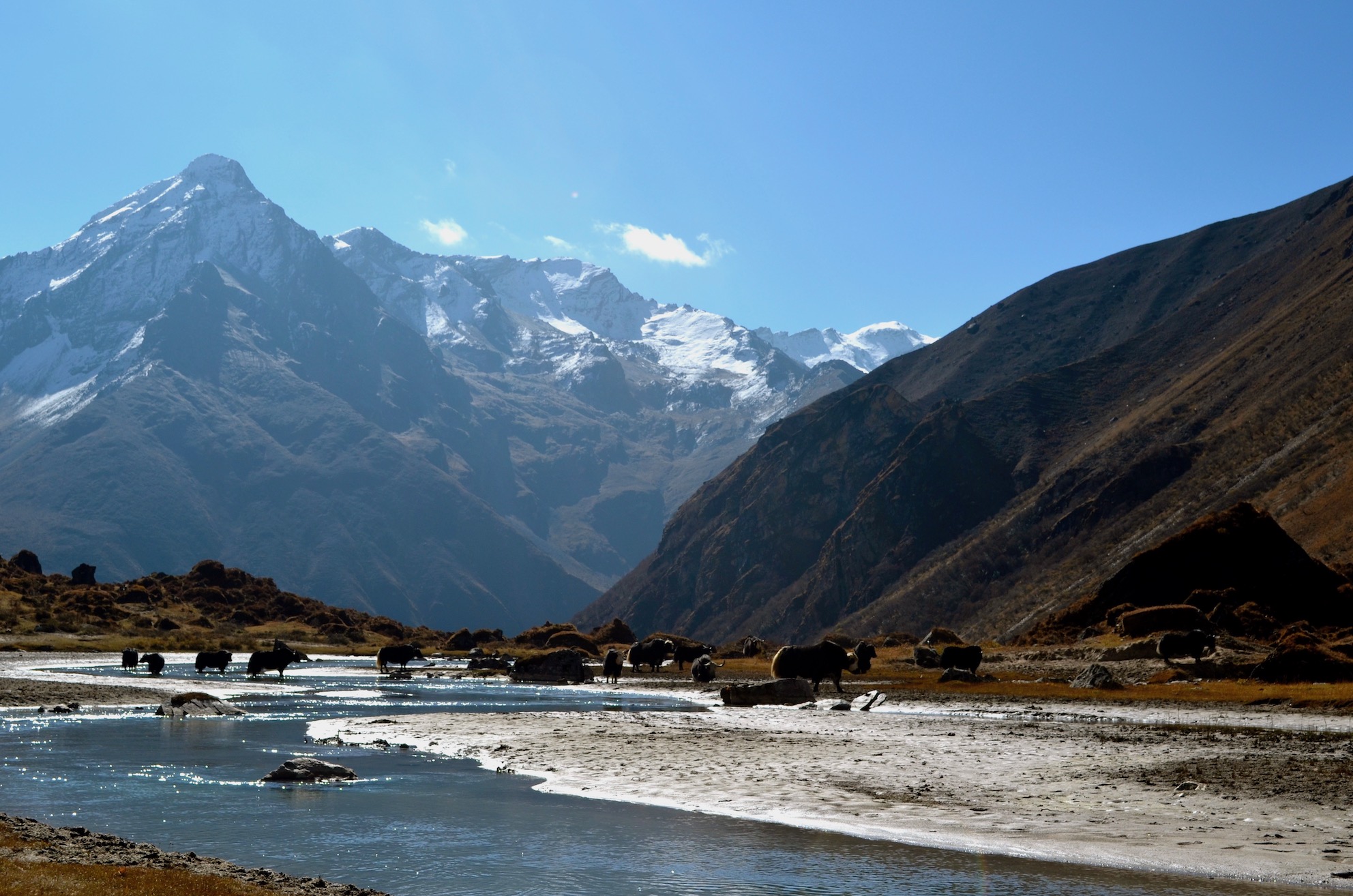
The day starts with a gradual climb through alpine vegetation, until the landscape opens up into a wide high valley. There is another army check point next to the trail, where our trekking permit will be checked. We are surrounded by high ridges and snow-capped mountains all the way to Jangothang. We may come across yaks and yak herder camps and will pass through small clusters of houses.
Thirty to forty minutes, on a flat trail, after Dangojang, which has a small school, we will arrive at Jangothang. This is Jomolhri base camp, a flat meadow, overlooked by the ruins of an ancient dzong. Mt Jomolhari is an imposing, snow-covered presence, at the end of a side valley.
Day 5: Jangothang halt.
Today we will do a side trip, following the yak trails that weave along the sides of the valley, to the base of Mt Jomolhari. Climbing to the top of the moraine, we walk along a ridge, overlooking the glacier that snakes down from the mountain. We often see herds of blue sheep, high on the ridges. Snow leopards have also been spotted in this valley. The walk to the glacier takes 5-6 hours return and we will have a picnic lunch on the way
Day 6: Jangothang – Lingshi village.
Distance – 19 km.
Walking time – 7- 8 hours.
Overnight Camp altitude 4150 m / 13612 fts above sea level.
Leaving Jomolhari base camp, we begin with a short flat walk before a steep climb, into a high basin. We may see yaks and marmots along the way. The trail levels for a while, until the start of a long climb to the Nyile La pass, at 4890 meters. We pass a chorten on an exposed ridge, before the final ascent to the pass, from where there are stunning views.
After the pass, there is a long, gradual descent into Lingshi basin. The vegetation is sparse and, as we approach Lingshi, there is a wide panorama across to Lingshi dzong, from a rise just off the trail, we look over Mount Tserim Kang and its glaciers to the north.
We camp next to the river in the valley bottom.
Day 7: Lingshi halt.
Today is a rest and acclimatization day. You may choose to relax in the campsite or explore Lingshi village, which is a short climb out of the valley, on a steep trail, opposite the campsite. Not far from camp, up the valley, is Geu Goemba, a small temple tucked away on a cliff face, on the north side of the river.
Day 8: Lingshi – Shodu.
Distance – 22 km.
Walking time – 7 – 8 hours.
Overnight Camp altitude 4080 m / 13380 fts above sea level.
We begin today’s trek with a half hour climb through rhododendron forest to a chorten, from where we look across to Lingshi dzong. We are now in a high valley, following the river and crossing several small streams along the way.
After a couple of hours, we cross the No Chhu and begin a steep climb into another high valley and then steeply up to the Yeli La, at 4950 meters. Prayer flags and cairns mark the highest pass of the trek. From the pass, we look down on our route for the afternoon, an initial steep descent, past isolated lakes.
Once down from the pass, we have a long gradual descent, with several river crossings, before we reach a flat meadow, marked by a chorten for the night.
Day 9: Shodu to Domshisa.
Distance – 21 km.
Walking time – 7-8 hours.
Overnight Camp altitude 3300 m / 10824 fts above sea level.
From Shodu, we follow the river downstream on an undulating trail, past an abandoned military camp. Limestone cliffs rise up on either side of the valley as we walk through a beautiful forest and past several waterfalls. It’s a long, gradual climb to Barshong, a ruined dzong, close to a small village.
After Barshong, the trail descends steeply on a switchback trail through a mossy forest to the Thimphu Chhu. A little over an hour after leaving Barshong, we will reach our campsite for the night: a flat clearing next to the river.
Day 10: Domshisa to Dodena – Thimphu.
Distance – 17 km.
Walking time – 6-7 hours.
We follow the river this morning, continuing through the forest, with some short climbs. Then it’s a steep climb up to a pass, from where we can see the progress of a farm road being built towards Barshong. If it’s wet, this section of the trail can be very muddy.
Our transport will meet us on the road, where we will farewell our trekking crew, before the drive back to the hotel in Thimphu.
Thimphu was established as the country’s capital in 1961, it has gone through drastic changes and has settled into a well-balanced mix of old and new, traditional and modern. It is the only world capital without traffic lights, yet with high tech karaoke machines Thimphu is ready for the new generation. The capital offers much more than just shopping.
End of Trek.
Overnight in Thimphu.
Day 11: Thimphu.
After breakfast we will spend our time circumambulating the sacred National Memorial Chorten. This is a Tibetan-style chorten built in 1974 in memory of the late King Jigme Dorji Wangchuk who passed away in 1972. It is one of the most visible religious structures in town and for many people it is the focus of daily worship. Remember to walk around the Chorten at least once to gain merit and good luck.
Next, we will drive up a ridge to visit the Biggest Buddha Statue at Kunesel Phodrang in Thimphu. This statue of Buddha measures 52 meters. It is one of the largest statues in the world. The statue is made of bronze and is gilded in gold. There are many smaller Buddha statues placed inside.
We will drive to the National Post Office for stamps. Bhutan is famous for producing unique and innovative stamps. After selling peculiar ‘CD-stamps’ Bhutan’s Post office now offers personalized stamps; we invite you to surprise your family and friends with your custom-made stamp made with one of your favorite holiday photographs!
Next, we will take in more of kingdom’s rich culture at the Folk Heritage Museum. The museum is a restored three story traditional rammed mud and timber house inaugurated as a museum by Her Majesty the Queen Ashi Dorji Wangmo Wangchuk in 2001. It showcases the traditional artifacts used now and, in the past, which helps connect people to the Bhutanese rural life.
Typical Bhutanese Lunch at the Museum restaurant.
After lunch visit the Bhutanese Paper Factory. The art of handmade paper in Bhutan dates back to the 8th century, although usage was limited mainly to religious purposes. Today it is considered an important element in the preservation of Bhutan’s cultural heritage. The factory allows guests to view the paper making process and purchase gifts from their show room.
We will also browse the striking collection of intricate textiles at the National Textile museum.
The Museum introduces you to the living national art of weaving. The exhibition displays the major weaving techniques and styles of local dress and textile made by the Bhutanese women and men.
In the evening you can stroll in the town, visit the Local Craft market just above the Textile museum and visit local handicraft shops.
Overnight in Thimphu.
Day 12: Transfer to Phobjikha valley.
Distance: 134 km
Driving time: 5 hrs 30 mins drive.
Altitude in Phobjikha: 2900 m / 9514 ft above sea level.
Phobjikha Valley is one of the most stunning areas in the country. The wide flat valley without any trees after the hard climb through dense forest is an extremely rare experience in Bhutan. In contrast to some parts of Bhutan, where modern development is already very apparent, Phobjikha is a place with natural beauty.
Before driving through the fir, juniper and rhododendron into the glacier valley of Phobjikha, after roughly 40 minutes’ drive, we will stop to stretch by hiking to Hongtso Goemba (1 hr hike). The Goemba was built in 1525 by Drukpa Kuenlay (the Divine mad man). It is a two-story traditional Bhutanese building where the main alter room has an enormous statue of Guru Tshoki Dorji in a standing posture together with his spiritual consort. Inside we can view very old wall paintings.
10 mins drive after the end of hike we will reach Dochula Pass (3000 meters). If weather permits, we will have great views of the extended eastern Himalayas in Bhutan.
From there we will continue our journey by winding our way into Wangdi valley (1300 meters) and then drive up until the neck of Pelela pass (3300 meters) where we will cut our way to take a diversion into the glacier valley filled with dwarf bamboos. The valley is one of the most important wildlife preserve in the country, because of the large flock of black necked cranes that migrates from Tibet in the winter.
In the evening experience Traditional Hot stone Bath followed by dinner at the Farm House.
Overnight in Phobjikha valley.
Day 13: Transfer to Punakha.
Distance: 87 km
Driving time: 3 hrs drive.
Altitude in Punakha: 1300 m / 4264 ft above sea level.
The sub-tropical valleys of Punakha and the surrounding mountain sides offer a large variety of attractive places to explore and discover monasteries and the most impressive Dzong in the country.
Today before driving to Punakha, we will visit the Crane education center. There we can watch the short documentary on the magnificent black necked crane and also look out for the cranes in the valley with the help of a binocular there.
Next, we will briefly visit the famous 16th century Gangtey Goemba that overlooks the large green expanse of the valley. The monastery is surrounded by a large village inhabited mainly be the families of the Gomchens (lay monk) who take care of the monastery.
After two hours of descend we will arrive Wangdiphodrang valley. There we will visit the Wangdiphodrang Dzong which was burnt down by fire in 2012.
After the visit we will decent our way into the Punakha valley. In just 2 hrs drive we will descend 1700 meters.
There we will hike to the famous Chimi Lhakhang (Fertility temple). The 30-minute walk from the road to the lhakhang is through open farmland. It is believed that a demoness who had been terrorizing the valley transformed herself into a black dog to escape the wrath of Drukpa Kuenlay, the Divine Madman. However, he caught the dog and buried it under a pile of earth shaped like a woman’s breast. He then built a chorten on top of this mount and prophesied that a temple would one day be consecrated over it. True to the prophecy, his brother, Lam Ngawang Chogyal, built Chime Lhakhang in 1456. If you are wishing for a child, it is believed by the Bhutanese that a visit to Chime Lhakhang, might help increase your chances! Hundreds of couples visit the lhakhang to pray to become pregnant and receive a wang (blessing). Many parents also bring their newborn children to receive the baby’s name from the local lama.
Overnight in Punakha.
Day 14: Punakha.
After early breakfast we will travel up the valley north and cross the Mo Chhu to hike up and pay respect to the grand Khamsum Yuelley Namgyal Chorten, The Chorten is 30 meters (100 feet) tall and can be seen in the distance when driving or walking up from the footbridge towards the lodge. The three-leveled chorten took eight and a half years to build and was consecrated in 1999. Dedicated to the Fifth King, it was built to remove negative forces and to provide peace, stability, and harmony in an ever- changing world. It is therefore filled with every form of colorful protector imaginable.
After Picnic lunch by the riverside we will drive down valley to visit the stunning Punakha Dzong. The Dzong is considered one of the most important and also one of the most beautiful Dzongs in the Kingdom. It was built by Zhabdrung in 1637, and was the seat of the government every winter until Thimphu was established as the permanent capital in 1955. It is still the winter residence of the Central Monastic Body.
Next, we will drive at a hill top to visit a Sangchhen Dorji Lhendrup Lhakhang (Nunnery) built by maternal grandfather of the king. The Nunnery also serves as higher learning institute and meditation center for Nuns. It is perched on a ridge overlooking the Punakha and Wangdi valley.
Overnight in Punakha.
Day 15: Transfer to Paro
Distance: 125 km
Driving time: 4 hrs drive.
Altitude in Paro: 2300 m / 7544 ft above sea level.
The journey west takes us back to Paro valley crossing the Dochula Mountain Pass, side stepping Thimphu city and following wang Chhu river and and Pa Chhu rivers before arriving in Paro.
Before arriving Paro, we will stop to visit the Tachogang Monastery. The temple of excellent horse built by Thangthong Gyalpo (Iron chain builder in Bhutan) in 15th century. Down by the river we can see one of his Iron Bridge. You will walk across the suspension bridge built just next to the Iron bridge to continue the climb up to the monastery. After the short stretch we will continue our drive to Paro for the last night.
Towards evening we will stroll around Paro Town is a must for all visitors who come to this valley. The town dates back from 1985 and its lined up by souvenir shops and café. If you are in for a good cup of café, stop at Mountain Café Roastery. They serve the best coffee in Bhutan.
Overnight in Paro.
Day 16: Transfer to Paro – International departure to your onward journey.